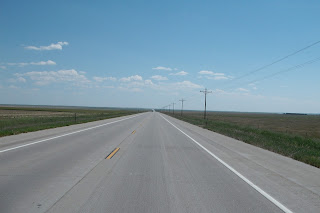
This photo was representative of the view from the highway
most of today. This is high prairie grassland, with some planted crops
and cattle grazing. Most cattle are in feed lots.
A view of the many wind turbines along the route.
Kt Carson, Colorado. Pop. 344. The sign on the local museum
provides the distance to Denver and Kansas City.
A view of the road. The road, as the flat open land, appears endless.
Another view showing a few of the wind turbines along my route of travel.
Day thirty. All is well. In southwest Colorado.
Today I followed secondary roads through Colorado, ending the day in Lamar, Colorado, which is approximately 30 miles west of the Kansas-Colorado state line on US 50. US 50 tracks the Santa Fe Trail. In the early 1800's it was the connecting route from Franklin, Missouri to Santa Fe, New Mexico. In the late 1800's the Union Pacific followed the same route, and later Highway US 50 did the same.
My travels today have been across high prairie grasslands. This land was once covered by buffalo. A history of the town of Kit Carson, Colorado includes the story of a Russian Archduke guided by General George Armstrong Custer killing a buffalo when the town was surrounded by buffalo.
Kit Carson, Colorado was founded in 1838, and took the name of the famous Kit Carson (He would live another 30 years from the founding.). There is no record of Carson ever being in the town that still bears his name. Since it was a railroad terminus for a brief time it was a wild place, with saloons, six guns, shootings, and even a lynching. Today it is a wide spot, with very few businesses, and not even a stop light. It seemed interesting, the name was a curiosity, and they had a nice old depot for a museum...so I stopped. This was my second visit to Kit Carson in the last four years, but my first time to find the museum open. Bought a T-Shirt.
The elevation from my start of the day was just over 5,000 feet. Lamar's elevation is 3,625, and it continues to drop as I travel east.
The land is semi-arid, and there is cultivation of the land, often with the assistance of irrigation. There were/are very few small towns along the route, and only a couple of slow-down areas in the last two hundred miles. The photos included represent most of the landscape, although there were a few areas of very low rolling hills.
I do not know the size of the wind turbines photographed, but they are huge. A quick search showed that the average height for new wind turbines is 275' and the rotor diameter is 308' (Recall that a football field is 300'.) One source said that a wind turbine that produces 2 MW of electricity cost $3-4 Million (I know ...a large range.) as an installed price. There were hundreds of these along my route of travel today. There were a few not turning, but nearly all were...clockwise.
And it was hot today. Like yesterday. Since this was a scheduled short day for me I missed the long ride in the hot sun....but I was there long enough.
Another good day.


No comments:
Post a Comment